The frame shows the islands that make up Venice and the Venetian Lagoon that surrounds them. The image was taken on June 22, 2008 from the commercial satellite Ikonos-2.
The photo shows the extraordinary landscape of the Tanezrouft Desert, one of the most uninhabited parts of the Sahara in southern Algeria. The image was taken on June 24, 2009 from the advanced Japanese ALOS satellite.
 Photo: JAXA, ESA
Fertile farmland in the Imperial Valley of Southern California, USA, imaged on July 4, 2010 by the ALOS 4-ton Earth observation satellite.
 Photo: ESA, 2009
A plankton bloom in the Barents Sea off the northern coast of Europe, captured by the Envisat satellite on August 19, 2009.
 Photo: ESA
The Jurua River (a right tributary of the Amazon) meanders through the Amazon rain forest in western Brazil. The image was compiled from three frames received from the Envisat satellite on January 2, February 1 and March 3, 2012.
 Photo: ESA
This Envisat satellite image shows snow clouds blanketing the North Sea and sweeping down toward the strait between Denmark (lower right) and Norway (top center). In the upper right, a more massive cluster of clouds covers southeastern Norway and extends over Sweden. Part of the Danish Jutland Peninsula is visible in the lower right corner.
 Photo: KARI/ESA
The image was taken on November 24, 2012 by the Kompsat-2 satellite. Before you is the Mangistau region in the southwest of Kazakhstan, east of the Caspian Sea. The road network in the lower left of the image is the Karakuduk oil field. White squares in the “web” indicate oil wells.
 Photo: KARI/ESA
The Kompsat-2 satellite captured rolling hills of farmland in the northwestern United States.
 Photo: European Space Agency
In this Envisat satellite image, the Ganges River delta in southern Asia is visible in the foreground. It is also the largest delta in the world.
 Photo: USGS/ESA
This artificially colored image was received on May 4, 2012 from the Geological Survey satellite LandSat-5. The arable agricultural lands of the American state of Kansas are divided into circles and rectangles due to the different types of irrigation systems used.
 Photo: ESA
The massive iceberg in the center of the image broke off from the Petermann Glacier in Greenland in August 2010. The Envisat satellite captured this image on May 4, 2011. From late May to late June, more than 1,000 icebergs flock into the southern part of the Labrador Sea, which is why the place is called “Iceberg Alley.”
 Photo: JAXA, ESA
Deep in the Sahara Desert, in southeastern Libya, lies the Al Jaf oasis, depicted in this image from Japan's ALOS satellite. The city can be seen in the upper left corner. The two parallel lines are the runways of Kufra Airport.
 Photo: KARI/ESA
The Korean satellite Kompsat-2 captured this image of southern and central Romania on January 2, 2013.
 Photo: ESA
Most of Siberia, which is visible in the photo, lies above the Arctic Circle. This is also a permafrost region. In the lower left corner stands out the Yenisei River, which flows north into the Kara Sea. Photo taken by Envisat satellite on March 5, 2012.
 Photo.
Russia is located in the northern part of the Eurasian continent. The country is washed by the Arctic and Pacific oceans, the Caspian, Black, Baltic and Azov seas. Russia has common borders with 18 countries. The area of the territory is 17,098,246 sq. km.
Plains and lowlands make up more than 70% of the country's total area. The western regions are located on the East European Plain, where lowlands (Caspian, etc.) and highlands (Central Russian, Valdai, etc.) alternate. The Ural mountain system separates the East European Plain from the West Siberian Lowland.
Map of Russia from satellite online
Map of Russia from satellite. Cities of Russia from satellite
(This map allows you to study roads and individual cities in various viewing modes. For detailed study, the map can be dragged in different directions and enlarged)
Russia is rich in huge reserves of fresh water. The largest rivers include: Lena, Angara, Yenisei, Amur, Volga, Ob, Pechora and others with their numerous tributaries. Baikal is the greatest freshwater lake.
The flora of Russia consists of 24,700 plant species. The largest number of plants is in the Caucasus (6000) and the Far East (up to 2000). Forests account for 40% of the territory.
The fauna is diverse. It is represented by polar bears, tigers, leopards, wolves and a huge variety of other animal representatives.
Oil reserves have been explored almost throughout the country. The Siberian platform is rich in coal, potash and rock salts, gas and oil. The Kursk magnetic anomaly includes the largest iron ore deposits, and on the Kola Peninsula - deposits of copper-nickel ores. In the Altai Mountains there is a lot of iron ore, asbestos, talc, phosphorites, tungsten, and molybdenum. The Chukotka region is rich in deposits of gold, tin, mercury, and tungsten.
Due to its geographical location, Russia belongs to different climatic zones: arctic, subarctic, temperate and partially subtropical. The average January temperature (in different regions) ranges from plus 6 to minus 50°C, July – plus 1-25°C. The annual precipitation is 150-2000 mm. 65% of the country's territory is permafrost (Siberia, Far East).
The extreme south of the European part includes the Greater Caucasus Mountains. The south of Siberia is occupied by Altai and the Sayans. The northeastern part of the Far East and Siberia is rich in medium-altitude mountain ranges. There are volcanic territories on the Kamchatka Peninsula and the Kuril Islands.
The population of Russia by 2013 was 143 million people. Representatives of over 200 nationalities live in the country. Of these, Russians make up approximately 80%. The rest are Tatars, Chuvash, Bashkirs, Ukrainians, Chechens, Mordovians, Belarusians, Yakuts and many others.
Russian peoples speak 100 or more languages belonging to the Indo-European, Ural, and Altai language families. The most common spoken languages: Russian (state), Belarusian, Ukrainian, Armenian, Tatar, German, Chuvash, Chechen and others.
Russia has the largest Orthodox population in the world - 75% of Russians. Other common faiths are: Islam, Buddhism, Judaism.
According to its state structure, Russia is a federal presidential republic. It consists of 83 entities, including:
— regions — 46,
— republics — 21,
— edges — 9,
— federal cities — 2,
— autonomous okrugs — 4,
- autonomous region - one.
Russia has enormous tourism potential. However, this area is still waiting for its development. At the moment, in addition to the usual resort tourism, a new direction is developing, for example rural tourism. There are different types of rural tourism: ethnographic, agricultural, ecological, educational, culinary (gastronomic), fishing, sports, adventure, educational, exotic, health and combined.
Rural tourism (agricultural tourism) is, first of all, surrounding nature on all sides, architectural monuments and historical places. Roosters crowing in the morning and fresh milk for dinner, natural food and tourist routes replete with beautiful views, holy springs, monasteries, deposits, the beauty of forests and fields, fishing on the lake, acquaintance with rural life, traditional crafts, the opportunity to join the village environment and cultural heritage, walking, cycling and horseback riding. In addition, rural tourism raises the role of local history.
This type of tourism is thriving in Europe, but in Russia it is still an incomprehensible curiosity, however, there are more and more people wanting to relax in the “country” style.
Such a vacation away from the bustle and noise of the city gives a tremendous boost of energy.
The public cadastral map, displayed with an overlay of satellite photographs (as of 2015), is a nationwide resource containing information about real estate. In general, this is a huge photograph of the country, assembled from many small photographs taken from space as part of the Esri or Scanex projects. The image is composed taking into account the global coordinate system. The main purpose of the service is to provide open (free) access to cadastral information to an unlimited number of users - ordinary citizens, realtors, lawyers, employees of surveying firms, and others. Since the implementation of the project in 2010, the procedure for obtaining cadastral information has been significantly simplified.
Information content of the resource
A public cadastral map from a satellite is the result of the work of many cadastral engineers employed by Rosreestr. With its help, you can find an object on the ground and recognize it:- 1 – cadastral number;
- 2 – address;
- 3 – area;
- 4 – cadastral value that will be used for taxation;
- 5 – form of ownership.
- 1 – receive and print a plan of the land plot and the corresponding cadastral quarter;
- 2 – clarify the category of lands, their boundaries and intended purpose;
- 3 – determine the location and boundary lines of neighboring objects;
- 4 – find out the details of the Rosreestr division that stores information about the object of interest;
- 5 – obtain information about capital construction projects. In addition to the above data, you can find out the number of storeys of the building, including underground, wall material, dates of commissioning and completion of construction, name of the contractor and his Taxpayer Identification Number;
- 6 – send a request to the State Property Committee, Unified State Register, obtain data about the object online.
Summary
A public cadastral map from a satellite is a unique tool that allows you to get an idea of where the property of interest is located, what its boundaries are, and what objects it is adjacent to. The resource is necessary to determine the location and status of land plots. This is very important when resolving controversial issues: for heirs, notaries and honest citizens defending their rights.Many users would like to enjoy satellite photos of their native places, to see their house, a nearby river or forest from above, in a word, everything that is commonly called “small Motherland”. A tool for realizing this desire can be satellite mapping services, which provide a unique opportunity to view all required geolocations in detailed graphic mode. After my attempts to look at my home online from a satellite, I found really high-quality services and in this article I will share my experiences.
What you need to know when searching for your home on an online map
There is a huge variety of mapping services on the Internet that provide the user with access to high-resolution satellite maps. At the same time, the vast majority of such services use the API from Google Maps, and only a few services (including the domestic Yandex.Maps) can boast of their own cartographic developments that differ from the dominant Google maps in this segment.
At the same time, working with such cards is quite formulaic. You go to one of them, turn on satellite display if necessary, and then enter your address (town, street, house number) into the search bar. After this, the service finds the required location, and you can use the mouse wheel to increase or decrease the existing display. If for some reason the service does not find your house, I recommend entering the name of the city (town, village) and street, and then find the desired house yourself using the mouse.

At the same time, some services allow you not only to see your house from above, but also to walk along the streets of your hometown and enjoy the view of the buildings we need up close.
Let's move on to the list of services that will help us see our home from satellite.
Google Maps - look at your home from satellite in real time
The most popular global mapping resource is undoubtedly Google Maps. In addition to maps presented in schematic and satellite form, the service also includes the ability to 360° view the streets of many cities around the world (Street View). Information about street traffic and traffic jams (Google Traffic), a route planner from point A to point B, 3D display of many geographical points, and other useful features.
There are two main options to view your home:

Yandex.Maps - will allow you to see the necessary object in Russia
Another mapping service with which you can enjoy the view of your home is Yandex.Maps. This service is the most popular in Russia, since the level of display of the territory of Russia and the frequency of updating data for the Russian Federation exceeds all existing analogues, including generally accepted maps from Google.
Like the Google Maps service, Yandex.Maps can boast of both standard and satellite display of maps (as well as the “Hybrid” mode, which involves applying various text and schematic markings on a satellite map). In addition, users have access to a street display mode (“Yandex.Panoramas”), a traffic congestion indicator (“Yandex.Traffic”), as well as the “People’s Map” crowdsourcing system, which can be edited by any user.

To view your home using Yandex.Maps, go to the resource, enter your address in the search bar at the top, and press enter. To switch to street view mode, click on the button with binoculars at the bottom of the screen (street panoramas and photographs). And then select one of the streets marked in blue (you will switch to the street view mode at this point, and you will be able to enjoy the color of these places).
Bing.Maps – satellite map from Microsoft
Bing.Maps is an online mapping service from Microsoft, formerly known as Windows Live Maps and MSN Virtual Earth. Its capabilities include satellite display of maps, street view, 3D display for 60 cities around the world, plotting the optimal route and other features that are standard for services of this type.

To watch your home using Bing.Maps, go to the specified service, click on “Road” on the right, and select “Hybrid View”. Then enter the address you need into the search bar and view the view that opens.
MapQuest is a popular American mapping service
"MapQuest" (translated as “Card Search”) is a free American mapping service, the second most popular in the United States after Google Maps. The resource boasts a high degree of detail on the streets of many countries around the world, will help you plot a convenient route, inform you about existing traffic, and much more.
To work with it, you need to go to this resource, click on the button with the image of the globe on the right (Satelite), which will allow you to switch to satellite display mode. After that, in the search bar on the left, enter the address you need (preferably in Latin), and enjoy displaying the desired location using the MapQuest service.
 MapQuest is the second most popular service in the United States
 Conclusion
You can view your home from satellite using the services I listed in this material. For the territory of Russia, I would recommend the Yandex.Maps service - the level of detail and frequency of updated data inspires us to consider maps from Yandex the best mapping service in the Russian Federation. On a global scale, the Google Maps service is the undisputed leader, so it would be optimal to use the tools of this service to display maps of many countries around the world.
Many users would like to enjoy the satellite map of Russia online, see any memorable places with which many bright and colorful memories are associated. Various network services that provide this opportunity in real time can help with this. In this material I will tell you where online you can look at maps of Russia from a satellite, and which network services are the best in 2019.
What should you keep in mind when using satellite maps of Russia 2019?
On the Internet you can find a large number of services that provide the opportunity to view the territory of Russia using photos taken from a satellite. The variety of such services should not be misleading - most of them use the API from Google Maps, some use the capabilities of Yandex.Maps, and a few use maps from the Bing service from Microsoft.
Working with such services is quite simple.

At the same time, a number of services (the same Google Maps and Yandex.Maps) allow you to use the “street view” mode, in which you can virtually walk along selected streets, enjoying the view around you.
Let's consider services that allow us to see a map of Russia from a satellite online.
Google Maps - viewing Russian cities from satellite
The most popular mapping service in the world in 2019 is Google Maps. It includes a mode for displaying the Earth's territory from a satellite, a street map (including a 360-degree panoramic view). Also, the state of street traffic in real time, planning optimal routes (for pedestrians, cyclists, car drivers), and other convenient features. To view the most popular and beautiful places on our planet, Google has created a service in which a panoramic view is available.
In order to open a map of Russia from a satellite in Google Maps at the bottom left, switch to satellite map display mode. Then, in the search bar, enter the name of the toponym you need in Russia, and press enter (or find it with the mouse).
To enable street view mode, there is a button with a hand-drawn yellow man at the bottom right.

Yandex.Maps - the best satellite map of Russia
Yandex.Maps is one of the most popular mapping services in Russia. Its popularity among the Russian audience is not surprising - the service boasts the highest frequency of data updates for Russia compared to its competitors (which is especially important for displaying traffic jams). At the same time, its functionality, in addition to satellite maps and the “Street Panoramas and Photography” mode (similar to Google’s Street View mode), includes a tool called “People’s Map”, which is a crowdsourcing data collection system in which each user can edit the map (with condition of moderation).
- To view Russia from a satellite, go to the yandex.ru service.
- In the search bar on the left, you can enter the data of the geographic location you need, or find the establishment you need nearby by clicking on the corresponding button.
- To switch to Street View mode, click on the “Street Panorama and Photos” button at the bottom right.

The initial screen of the service from Yandex makes it possible to quickly find the desired establishment nearby
Infokart.ru – detailed map with views of streets and houses
The domestic service infokart.ru is good primarily because it combines on one page of the site both the functionality of the Bing satellite maps from Microsoft and maps of the non-profit web map project OpenStreetMap.org, allowing you to view maps of Russia from a satellite online.
By going to the infokart.ru service page, you can enjoy both satellite maps of Russia and a detailed map of many Russian cities.

Wikimapia with details down to cities and houses
The international project "Wikimapia" is an online geographical encyclopedia that combines the API from Google.Maps with the principle of free data editing adopted by Wikipedia. The founders of the project were domestic developers Alexander Koryakin and Evgeny Savelyev in 2006. Now the project unites more than 2.5 million users who have entered information about tens of millions of objects into the system database.
The goal of the project is to collect and organize data about geographic objects, information about which can be obtained by anyone.
- To use the site, go to wikimapia.org.
- Select the Russian interface at the top (instead of EN - RU), then in the search bar on the right, enter the name of the object you need to view it.
- To enter your own data (the “Add object” button), or edit existing ones (the “Edit” button), you will need to register in the system.
- The “Categories” button will allow you to search by the desired category (shops, stadiums, hotels, parks, etc.).

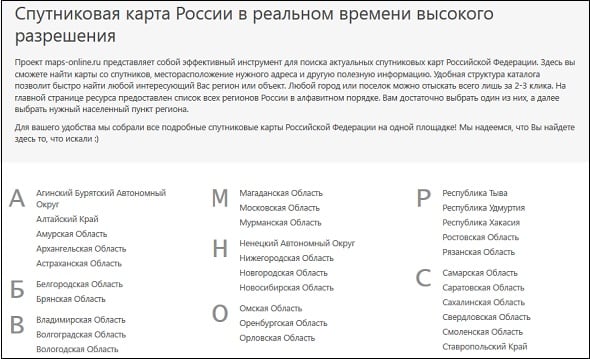
Maps-online.ru – cataloged map service
A special feature of the maps-online.ru card service is properly cataloged information. When you go to the resource, you can select the region of Russia you need, then the region, and the locality.
During the viewing process, you can also choose which satellite maps you need - from Google or from Yandex.
Conclusion
Using the services I have listed, you can easily view maps of Russia from a satellite online. All you have to do is launch the service you like, type the name of the desired locality in the search bar, and then view the resulting image, zooming in or out using the mouse wheel. To display Russia, I can recommend maps from Yandex 2019 - they have a high level of detail and a good frequency of updated data.


 Key Specifications")


 Key Specifications")


