Google Maps is a leader among modern mapping services that provide satellite interactive maps online. At least a leader in the field of satellite imagery and in the number of various additional services and tools (Google Earth, Google Mars, various weather and transport services, one of the most powerful APIs).
In the field of schematic maps, at some point, this leadership “was lost” in favor of Open Street Maps - a unique mapping service in the spirit of Wikipedia, where every volunteer can contribute data to the site.
However, despite this, the popularity of Google Maps remains perhaps one of the highest of all other mapping services. Part of the reason is that Google Maps is where we can find the most detailed satellite photos for the largest regions of any country. Even in Russia such a large and successful company as Yandex cannot surpass the quality and coverage of satellite photographs, at least in its own country.
With Google Maps, anyone can view satellite photos of the Earth for free almost anywhere in the world.
Image quality
The highest resolution images are usually available for the largest cities in the world in America, Europe, Russia, Ukraine, Belarus, Asia, Oceania. Currently, high-quality images are available for cities with a population of more than 1 million inhabitants. For smaller cities and other populated areas, satellite imagery is only available in limited resolution.
Possibilities
Google Maps or “Google Maps” was a real discovery for Internet users and indeed all PC users, giving an unheard of and previously unseen opportunity to look at their home, their village, cottage, lake or river where they vacationed in the summer - from a satellite. To see it from above, from a perspective from which it would be impossible to see it under any other circumstances. The discovery, the very idea of giving people easy access to satellite photos, fits harmoniously into Google's overall vision of “easily providing everyone with access to any information on the planet.”
Google Maps allows you to see from a satellite simultaneously those things and objects that cannot be observed at the same time when observed from the ground. Satellite maps differ from ordinary maps in that on simple maps the colors and natural forms of natural objects are distorted by editorial processing for further publication. However, satellite photographs preserve all the naturalness of nature and the objects being photographed, natural colors, shapes of lakes, rivers, fields and forests.
Looking at the map, one can only guess what is there: a forest, a field or a swamp, while on satellite photography it is immediately clear: objects, usually round or oval in shape, with a unique swamp color, are swamps. The light green spots or areas in the photograph are fields, and the dark green ones are forests. With enough experience in orientation in Google Maps, you can even distinguish whether it is a coniferous forest or a mixed forest: coniferous has a browner tint. Also on the map you can distinguish specific broken lines piercing the forests and fields of the vast Russian expanses - these are railways. Only by looking from a satellite can one understand that railways have a much greater influence on the natural landscape surrounding them than roads. Also in Google Maps, it is possible to overlay maps with the names of regions, roads, settlements on a national scale and the names of streets, house numbers, metro stations on a city scale on a satellite image of an area or city.
Map mode and satellite view mode
In addition to satellite images, it is possible to switch to the “map” mode, in which it is possible to view any territory on the surface of the Earth and study in detail the layout and location of houses of any more or less large city. In the "map" mode it is especially convenient to plan your movements around the city if you have already seen enough satellite views of your city.
The search function by house number will easily point you to the desired house, giving you the opportunity to “look around” the area around this house and how you can drive up/approach it. To search for the required object, just type in Russian in the search bar a query like: “City, street, house number” and the site will display to you the location of the object you are looking for using a special marker.
How to use Google Maps
To begin, open some place.
To move around the map, left-click on the map and drag it in any order. To return to the original position, press the centering button located between the four direction buttons.
To enlarge the map, click on the button "+" or roll the mouse roller when the cursor is over the map. You can also enlarge the map double click mouse in the location you are interested in.
To switch between satellite, mixed (hybrid) and map views, use the corresponding buttons in the upper right corner of the map: Map / Satellite / Hybrid.
Can you find satellite photographs that will help you trace the stages of the destruction of Donetsk airport as a result of artillery shelling?
To answer this question, this article will look at three online applications for finding historical satellite photos: , Terraserver and Digital Globe.
For different territories, satellites photograph the Earth's surface at different frequencies, depending on the population of the territory and the interest of users. Therefore, large cities will have more photographs than villages.
Before you start searching for historical photographs, you need to determine the geographic coordinates of the places you are looking for - longitude and latitude. One of the easiest ways is to use Google Maps.
For example, to get the coordinates of Donetsk airport, you first need find it on the map using the Google Maps search engine (in the upper left corner). Next, right-click on the map location that interests us (on the airport building) and select “What’s here?” in the list that appears.
Google Maps, “What’s here?”
A brief description and geographic coordinates of Donetsk Airport will appear in the upper left corner of the screen under the “Search” line - 48.067663, 37.741608.

You can also use the convenient online service Mygeoposition.com (uses Google maps) with a clear interface.
On the start day, you need to install the Google Earth program, that is, download it from the link - https://www.google.com/earth/— and go through the installation procedure lasting 5-10 minutes.

In the upper left corner in the “Search” line you need to enter either the coordinates (48.067663, 37.741608) or the name of the object (“Donetsk Airport”). Afterwards the program will show the latest satellite image of the area. You can get closer or further away from an object using the navigation bar like in Google Maps in the right corner of the program.

Google Earth. Navigation
To be able to view historical photographs, you need to select “View” - “Images in time” in the program menu.

A blue bar will appear in the upper left corner on a black background, indicating the valid time range for searching for photos. Light blue vertical bars indicate the dates of available photos. Using the slider or back/forward buttons, you can move through the timeline of historical satellite photos.

In our case, the last available image of Donetsk airport from space was taken on September 3, 2014. By clicking on the “Back” button, you can watch the process of destruction of the airport building. For example, in the photograph dated July 21, 2014, such damage is no longer visible.


TerraServer
If you can't find satellite images of a certain period in Google Earth, you can try searching on the American commercial site Terraserver. You will have to pay for high-quality photographs (from $25 to $225, depending on the image size). But free images can also help.
On the main page you need to enter either the longitude/latitude of the object (Coordinates), or indicate the country/city/street (Address) of the desired area.

TerraServer will show the most recent image available. To view historical photographs from a satellite, you need to click the More Images button, after which a list will appear indicating the date and time of available satellite images.

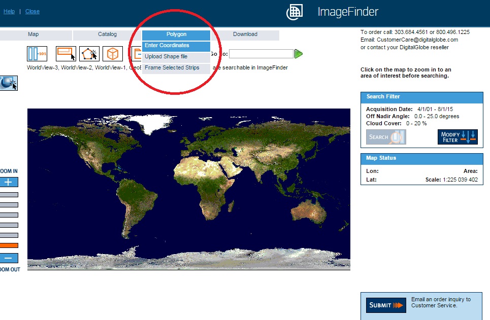
is also an American company that photographs millions of square kilometers of the Earth's surface every day, supplying images to NASA, Google, TerraServer.
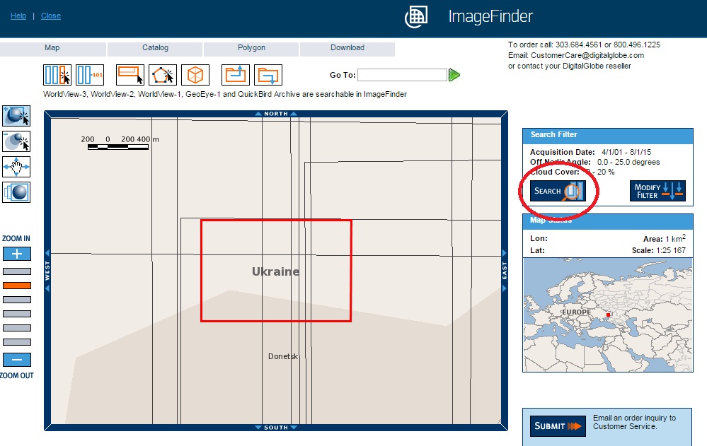
To go to the section with satellite photos, you need to click on Menu – ImageFinder.
On the ImageFinder page, as in similar services, you can search either by object name or by coordinates. To specify coordinates, select the Enter Coordinates button in the Polygon menu.
DigitalGlobe. Search by coordinates
On the new page, in the Center point tab, you need to indicate the coordinates of the Donetsk airport, and in the Area field, enter, for example, 1 (square kilometer), and click Continue. In the Corner Coodrs tab, you can set the terrain search parameters by specifying the coordinates of the upper left and lower right corners.
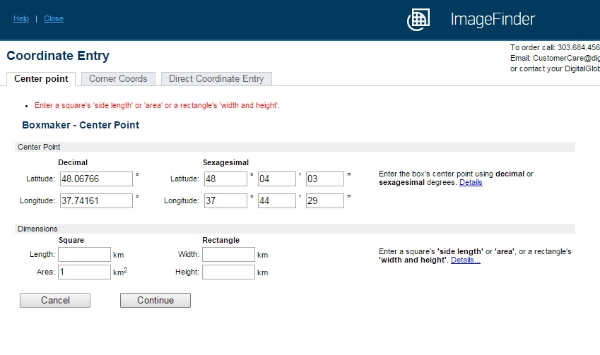
The next step is to click on the Search button on the right side of the screen.
All people know about the beauty of planet Earth, but previously only astronauts had a chance to verify this. Now every computer user with Internet access has this opportunity. The satellite view is broadcast in real time on many sites that are easy to find via Google, viewing is absolutely free.
Where to watch the satellite view in real time
For those looking for options on how to view the Earth from a satellite in real time, there are several options. The first of them offers a video broadcast from the ISS (International Space Station), on which one of the teams mounted a camera aimed towards the planet. You won’t be able to see the entire globe from the station online (the image only captures a part), but you are guaranteed fantastic sunsets and sunrises. In the second option, you can study a specific area using images from space in several formats (cartographic, satellite).
Earth from space online in real time
Planet Earth from the satellite is transmitted live with a delay of one or two minutes around the clock. If you don’t see anything when you go to the site, it means the surveillance footage is being taken from the dark side of the planet (where it is currently night). Those looking for a way to watch Earth from a satellite in real time should visit ustream.tv/channel/live-iss-stream. This is an official NASA live stream that can be found on many other sites, but this service is the original source.
There you can also find the station’s flight schedule and find out at what moment it flies over Russia. Sometimes, together with the ISS employees, a program is drawn up, according to which they go on video communication. They communicate, show and talk about interesting facts in space. Satellite Earth in real time and communication with staff occurs online every day.

Real-time satellite maps
A view of the Earth from space does not have to be in video format. Satellites flying in orbit every day are capable of taking a huge number of photos, which are then used to compile maps of the area. The pictures are so detailed that each person can find not only their city, but also their specific home. Several companies collect satellite data about the Earth and then offer their data.
An example is the website meteosputnik.ru. This project uploads photos from low-orbit metrological geostationary stations on the planet to the network. The service accepts images taken in real time. They are posted immediately after the end of data transfer. The site offers two formats of Earth photos for viewing: HRPT and ART. They differ in resolution and range of images received.
Google planet earth online
One of the most popular plugins for viewing images of the Earth is the Google Earth plugin. It is installed on a computer and provides the opportunity to view and even “visit” the most remote corners of the planet. The service offers, if desired, to go on a virtual “flight” around the globe. You can use standard GPS coordinates for moving; in addition to the plugin, images of other planets that were taken at the stations are provided.

Nov 11, 2015 13:06
grudeves_vf97s8ycThe public cadastral map, displayed with an overlay of satellite photographs (as of 2015), is a nationwide resource containing information about real estate. In general, this is a huge photograph of the country, assembled from many small photographs taken from space as part of the Esri or Scanex projects. The image is composed taking into account the global coordinate system. The main purpose of the service is to provide open (free) access to cadastral information to an unlimited number of users - ordinary citizens, realtors, lawyers, employees of surveying firms, and others. Since the implementation of the project in 2010, the procedure for obtaining cadastral information has been significantly simplified.
Information content of the resource
A public cadastral map from a satellite is the result of the work of many cadastral engineers employed by Rosreestr. With its help, you can find an object on the ground and recognize it:
- 1 – cadastral number;
- 2 – address;
- 3 – area;
- 4 – cadastral value that will be used for taxation;
- 5 – form of ownership.
If necessary, you can:
- 1 – receive and print a plan of the land plot and the corresponding cadastral quarter;
- 2 – clarify the category of lands, their boundaries and intended purpose;
- 3 – determine the location and boundary lines of neighboring objects;
- 4 – find out the details of the Rosreestr division that stores information about the object of interest;
- 5 – obtain information about capital construction projects. In addition to the above data, you can find out the number of storeys of the building, including underground, wall material, dates of commissioning and completion of construction, name of the contractor and his Taxpayer Identification Number;
- 6 – send a request to the State Property Committee, Unified State Register, obtain data about the object online.
Summary
A public cadastral map from a satellite is a unique tool that allows you to get an idea of where the property of interest is located, what its boundaries are, and what objects it is adjacent to. The resource is necessary to determine the location and status of land plots. This is very important when resolving controversial issues: for heirs, notaries and honest citizens defending their rights.
Satellite map of Russia - high-resolution images taken from space by orbital stations. The image that the user sees consists of many individual images. The high quality of equipment used at orbital stations made it possible to achieve the highest quality of imaging. As a result, on the screens of mobile devices and PC monitors, we have access to high-precision, high-resolution images, the image of which is very accurate and clear.
The satellite map of Russia displays high-resolution images in real time. You can see almost all Russian cities on them. By zooming in and out of objects, moving the cursor over individual sections of the map, you will be able to view streets, buildings, individual structures and squares. The larger the city, the more detailed the satellite map section will be for it.
Satellite map online in real time 2016 - exploring the country together
High resolution satellite maps online 2016 - a set of high-precision images through which you can study settlements of different sizes at a specific point in time. The user, selecting the object and scale he needs, receives a snapshot of it at the same point in time. By selecting the appropriate parameters instead of the “satellite view” mode, you can display the image:
- landscape view;
- schematic representation of Russia and its individual cities;
- Satellite view - real image.
Online high-resolution satellite maps of 2015-2016 are the most user-friendly models of interactive map images from the website service. They will allow you to travel throughout the entire state, from anywhere in the world. Satellites make it possible to track current data on the location and condition of various muddy objects from different settlements in vast Russia.


