I was impatient to use GPS for all sorts of electronic crafts. I reviewed a bunch of options and eventually formulated my wishes:
The lowest possible price
- dust and moisture resistance - so that you can screw it into the car, for example
- no non-standard chips - only the filling for which there is a lot of documentation
- no USB - just hardcore daisy-chaining so that you can use it in simple crafts.
And it worked!
When you just start looking for a suitable piece of hardware for an Arduino or some other microcontroller, something like this comes into your head en masse:
Paying dollars for thirty-forty-fifty, GPS is soldered - and if you are going to hide a piece of work, for example, under the hood of a car, please buy another GPS antenna and an adapter for it for extra money. At this point, the amphibian shakes its head negatively :(
Another option is GPS receivers for a computer with a USB cable, they are cheaper. If you choose this option, you will have to pay $ 20 for a USB shield and hope that you will be able to find a protocol decryption for a specific Chinese industry product. Well, or connect an old unnecessary Android smartphone via a USB-shield, but then goodbye to the speed of switching on and hello to the sea of problems - with the battery, turning on, brakes, etc.
And then I find this on DX:
The device is not even made in China, but in Taiwan by a GPS specialist company, and this model is designed for use on boats, has moisture protection and even a built-in magnet for attaching to the roof and a suction cup for installing on glass. Inside - de facto standard - SiRF Star III chip. And the price tag for this miracle is a little less than $ 35!
The unit has 2 variations - with USB and with a serial port (model), I make sure that I take the second one and order. While the Russian Post is slowly dragging the parcel, I delve into the documentation.
All "serial" peripherals have 2 implementations - "RS-232" and "TTL". The first was used ten years ago for modems and mice - it uses a current from minus N volts to + N. In modern microcontrollers, incl. Arduino, the second is used - where, when transmitting data, "ones" are indicated by a current of +5 volts (or 3.3 volts), and "zeros" are indicated by a lack of current. After reading the screams "oh, and I stuck it into the Arduino, but it does not plow!" realized that I also needed a TTL / RS-232 converter. First, I looked for the MAX3232 chip, which is usually used for these purposes, and then found it already wired for a couple of cents more, with connectors:
We start, and we see that the unit on the windowsill caught 11 satellites and determined the coordinates with an error of several meters:

As you can see, no additional power was required - there is enough current from the usual 0.5A USB port - i.e. and the microcontroller will handle it. At the same time, everything works through one and a half meters of the cable of the GPS receiver itself and three meters of the extension cord. More than enough to cram the microcontroller in the car, and put the GPS, for example, above the upper edge of the windshield.
The speeds are fully consistent with those stated in - "cold start" - less than a minute, "hot" - a second.
In total, for about forty bucks, I got a kit that turns any Arduino craft into a more interesting piece. Personally, I will make a GPS tracker out of it for a car with GSM, OBD-II connection to the on-board computer and other small joys.
Additions at the request of commentators:
Russian-language instruction: Half of the pages describe the connection to a PDA with Windows Mobile, however.
Link in large letters - (pdf). Weight - 62 grams, current consumption - 80mA, protocol - NMEA 0183 or binary. Cold start - 42 sec., Warm - 38 sec., Hot - 1 sec. The refresh rate with out-of-the-box settings is 1Hz, however, the specification says “reacquisition - 0.1 sec”.
I plan to buy +50 Add to favourites I liked the review +47 +890. Introduction
All of you have probably already come across GPS navigators. So, before you dare to buy this device - remember: not all gps navigators are created equal!
It’s somewhere abroad you can go to a store and buy a good product. In our country, going to the store, you need to know what exactly you want to buy, and how much should it cost. Otherwise, they will fuck you like a sucker and rip off like sticky.
And now, with enviable constancy, there are people who come to "Eldorado", call the seller, and say: "I need a gps-navigator." And they come out of this store with outright shit, bought for a lot of money.
For example, recently comrades bought a fancy Pioneer Avic S2 per 10.000 rubles with functions:
... bluetooth handsfree adapter for cell phone
... MP3 player
... multimedia photo viewer
In short, all functions, except for one and only one - navigation. What a trifle ...
Because it did not occur to the comrades when buying a navigator to ask the seller one single question: " Is there a map of our city there?"
Because it doesn't occur to a fucking company iGo that Russia is not only Moscow and St. Petersburg - but also a lot of different small cities, such as Lipetsk, Voronezh, Saratov, Orel and Uryupinsk, etc.
Because it does not occur to the eblans from Eldorado that it is not necessary to sell navigators on the Russian periphery, for which there are no maps of this very periphery, there were no, and the near future is not expected - due to the futility of this occupation for a foreign developer.
1. Comparative analysis of navigation systems
Meanwhile, if my comrades were in the subject, they would buy Garmin Nuvi 205 per 8.000 rbl- for which there are maps of 63 regions of Russia, all regional centers are plotted at least - with the names of streets, and half - with the contours and numbering of houses.
But no, our store shelves are littered with all kinds of TomTom, Nec, Pioneer, and a bunch of noname Chinese handicrafts like MIO, Orion or Shivaki... There are also completely mysterious devices with the only inscription "GPS" on the face.
Having become the happy owner of this device, people are disappointed to find that their 500,000th city on the map is depicted by a single point at the intersection of federal highways. And more or less detailed maps are available only for Moscow, St. Petersburg, and at best a dozen large cities in Russia.
Here is a brief comparative analysis of the coverage of navigation maps as of 03/01/2009:
Not the current moment in terms of cartographic coverage is undoubtedly the leader of Garmin, in second place is Navitel. The rest of the navigation systems are suitable, perhaps, only for those who prefer not to drive their car outside the Moscow Ring Road.
3. Types of GPS navigators
If you got a Garmin navigator - rejoice: you can buy (or download;) fresh maps - and drive on them.
If you have a PDA for Windows Mobile or Palm OS, or a smart phone for Symbian - not a problem either: download Garmin Mobile XT, unlock, fill in the cards - and get a full-fledged Garmin.
But what if you already have a certain hardware navigator with software that doesn't suit you at all?
4. What is PNA?
Globalization and laziness of manufacturers have obvious benefits. A huge number of devices have appeared on the market now PNA(Personal Navigation Assistant) - based on .. Windows CE! All Pioneer "s, MIO, JJ-Connect" s are just such devices.
A short theory so that you understand what it is about. In fact, such a device is a miniature computer with a miniature Windows, controlled by a touch screen instead of a mouse. True, the manufacturer took all measures so that you would never guess about it: instead of a Windows screensaver, there is usually a manufacturer's screensaver, instead of a desktop, there is a special program that restricts the user to the operating menu of the device with its own navigation and system settings.
PLUS - by bypassing the manufacturer's shell and gaining access to Windows, we can install a bunch of necessary and original ones on the device software, and generally use it as a full-fledged PDA. Craftsmen report the installation of various games, book readers, video players and even office applications on car navigators.
MINUS is a PDA, and a PDA under Windows. A Windows, as you know, is able to glitch, and sometimes even topple. Although WinCE is claimed to be an operating system with increased stability, careless user actions when communicating directly with Windows can turn your pna into an unresponsive useless device.
5. Installation files
Some smart manufacturers (for example Pioneer) put two flash drives on the PDA - a working and a backup - always available for reading only, and make it possible to produce the so-called " cold reset"- when the contents of a working flash card with installed Windows and software are overwritten by the contents of a backup flash drive. On the one hand, it is reliable - it is rather problematic to bring such a PDA to an inoperative state. On the other hand, it is not very convenient: all the software you have installed can be destroyed with one press of the handle and replaced with the standard factory system.
Getting out of this situation is quite simple: a standard file is put in the root of the external SD-card autorunce.exe, which starts automatically after a cold reset and card detection, and installs all the necessary software from the mnavdce.cab file.
You can download a set of the most commonly used WinCE utilities from here: utils.zip... I recommend downloading and unpacking them into a separate directory on an SD card - they will come in handy for us.
7. Vlazim inside
So, we have before us turned off pna with a standard menu. Usually there are commands "Navigation", "Applications" and "Settings". When you click on the Navigation button, some third-party software is launched, for example:
Autosatellite on JJ-Connect "e
... Navitel Navigator on Shivaki
... iGo on Pioneer "e.
Thus, on standard pna, there are two shells: the first shell shows the menu, and the second one does navigation. However, the WinCE desktop and taskbar are hidden. " Unlock"devices can be executed in several ways, depending on the device and what exactly you want to achieve.
Option 1: replacing the navigation program with another
... Option 2: replacing the standard menu with your own custom one
... Option 3: cancel all software shells and start the desktop
We will consider the first option as the safest one. The second and third unlocking options should be done very carefully, since some devices disconnect from the outside world and stop responding to events if they fail to launch the navigation menu.
If you still want to unlock your pna to the pda level - read the corresponding topics on the forum. And before doing this, pay special attention to the topic " How not to kill your own navigator ".
This is especially true for those who have a navigator with a single flash drive, and the "reset" hole on the side of the device does not fully restore the OS and all installed programs - but just a regular reboot. Note that there are MOST of such navigator models.
An awkward movement in the registry, or an inadvertent launch of the formatting of the system flash card from the Control Panel - will lead to large hemorrhoids in attempts to revive the device.
8. We start unlocking
Remember one axiom: despite the fact that all unlock methods are similar, there are no universal methods that would fit any device without changes. Therefore, performing each unlock operation, you need to understand what exactly you are doing now, and what consequences this will lead to.
The first and second unlock options are usually reduced to replacing exe-shnik navigation program or start menu to the desired application (for dummies, a detailed explanation).
First, you need to understand how the device connects to your computer. An external SD card of the device can always be shoved into a card reader, and the device itself is usually connected with a USB cord. There are two options here: either it is directly seen in the system as a disk drive, or in order to exchange files with the device, you will have to install Microsoft ActiveSync.
That is, we need to get file system access the device itself, and its external SD card. After that, empirically, we find (guess) where the exe-file of the navigation program lies. Depending on the manufacturer of the device, it can be located on a memory card, or maybe on an internal flash card of the device.
For example:
... \ SDMMC \ Navitel \ Navitel.exe
... \ SDMMC \ MobileNavigator \ MobileNavigato r.exe
The first thing I usually do is rename the old exe-shnik - for example, by appending the character "1" to the name: MobileNavigator1.exe. And in its place we put the already familiar one on cecmd.exe, named by its original name: MobileNavigator.exe.
Humanly disconnect the navigator from the computer, reload it, wait for the menu to appear, and select the "Navigation" item. If everything is done correctly, instead of the navigation program, you will see the file manager Total Commander for WinCE.
9. Examine the device
What does it give us? Firstly, you can search for information on the network not only by the name of the device, often unknown to Yandex and Google, but also by the system's code identifier. It happens that devices sold under different brands are completely identical inside.
Secondly - now we know for which OS version, processor and screen resolution we should look for software.
Do you want to get a full-fledged PDA from the navigator? Go to the \ WINDOWS folder and run explorer.exe. Then use the TaskbarShow.exe utility from the Utils.zip package. And here you have a full-fledged PDA, with a Start menu and a taskbar.
10. Meet the Garmin Mobile XT
The further action plan is clear: instead of the Exe-shnik, we need to fasten what we need. It can be one of several programs that provide an interactive user menu. In it you can integrate the launch of any navigation systems, toys, and just different programs.
In our simpler case, it should be a program-based navigation system Garmin Mobile XT- allows you to work with Garmin maps. The main problem is that the official versions of this program are released for Windows Mobile, Symbian and Palm - but not for WinCE.
If a year ago this problem was insoluble, now the craftsmen have already released several Garmin Mobile XT packages for WinCE. This became possible due to the fact that the kernels of the WinCE and Windows Mobile systems are largely identical.
Here are the links to these packages:
... GarminMobXTWinCE.zip
... GarminMobileXTforWindowsCE_50010w.rar
... GarminMobileXTforWindowsCE_50020w.7z
It is difficult to say which package will suit your system. If you have WinCE version 5.00.20 - I recommend starting with GarminMobileXTforWindowsCE_50020w.7z, if below - with GarminMobileXTforWindowsCE_50010w.rar You can also find many other assemblies on the net, including those for unlocking specific devices.
11. Script for starting Garmin
To run Garmin Mobile XT on WinCE it is not enough to call Que.exe. The good thing about assemblies is that they already have a built-in MortScript script to launch the application. This script is usually named Garmin.mscr and contains the following actions:
1) Check: if Garmin Mobile XT is already running - then just activate its window:
If (WndExists ("Garmin Mobile XT")) Show ("Garmin Mobile XT") Exit EndIf
... 2) Run explorer.exe(if it is not running yet). If your GMXT crashes with the error "Read access violation at data address 0xFFFFFFFC", then most likely you do not have explorer.exe running, but you need garmin:
If (not ProcExists ("explorer.exe")) Run ("\ windows \ explorer.exe") Sleep (400) EndIf
... 3) Despite the fact that explorer.exe is needed for garmin to work, task bar will only get in the way and obscure his window. To get rid of it, we will use the TaskbarHide.exe utility from the same Utils.zip:
Run (SystemPath ("ScriptPath") \ "TaskbarHide.exe") Sleep (500) Run (SystemPath ("ScriptPath") \ "TaskbarHide.exe")
... 4) Copy settings GMXT from SD card to the device's internal flash drive. If you do not save the settings on the SD-card, the program will forget them every time, starting with the default settings.
XCopy (SystemPath ("ScriptPath") \ "Settings \ *. *", "\ Garmin", TRUE)
... 5) Run Garmin Mobile XT and we are waiting for the completion of its work:
RunWait (SystemPath ("ScriptPath") \ ".. \ Apps \ WM \ que.exe")
... 6) After the application is finished, we pick it up settings back to SD card:
XCopy ("\ Garmin \ *. *", SystemPath ("ScriptPath") \ "Settings", TRUE)
... 7) We return the taskbar to its place. Otherwise, the next time you start explorer "and it will not be visible:
Run (SystemPath ("ScriptPath") \ "TaskbarShow.exe")
... 8) We shoot explorer.exe- usually the navigator does not need it:
If (ProcExists ("explorer.exe")) Kill ("explorer.exe") EndIf
Here's a script that turned out. Let's start and try. If at startup we receive the message "" ProcExist "requires toolhelp.dll" - add the library to the directory from scripts toolhelp.dll from the Utils.zip package.
12. Unlock Garmin Mobile XT
  |
Having heard that the program will not work without a Garmin GPS-receiver - we select the language and get to the main menu of the program. If you see this picture, 3/4 of your difficult path has already been passed. We go to the menu "Settings" -> "About the system", and rewrite the ID of the memory card (usually consisting of 10 digits) on a piece of paper.
 |
In line Unit ID enter the ID of the memory card. In the Software Product line, select Garmin Mobile XT. Press the top Generate button. You will get a serial for unlocking Garmin Mobile XT for third-party (not Garmin) GPS receivers. On a mobile device, in the Garmin folder, create a text file sw.unl
We continue to work with the key generator. In line Map Product indicate. A dialog box will appear. For the set of maps "Russian Roads version 5.xx" enter FID = 1280, click OK. Press the bottom Generate button. We receive a serial for unlocking "Roads of Russia" cards on this device. On a mobile device, in the Garmin folder, create a text file gmapsupp.unl We write a single line into it - with the resulting serial number - at least with the help of the Notepad editor.
If everything is done correctly, the program is jailbroken.
13. Install maps
Establishing the basemap of the world for the Garmin Mobile XT. To do this, download the file from the official garmin website GarminMobileXTFreeBasemap_4xxxx.exe... We start the installation, the program finds the memory card in the card reader, and itself offers to install there.
If your GMXT assembly for WinCE did not include Garmin Mobile XT voice files (you can see their availability in the Voice folder) - download from the official site GarminMobileXTSupportFiles_4xxxx.exe... We launch the installation in the same way, the program finds the memory card of our mobile device, and itself offers to install there.
We get a map from the Internet " Roads of Russia 5.11"It should be an .img file about 490 MB in size. If there is nowhere to get it, we tear it out of the official distribution kit map_updater_5_11.exe, which can still be downloaded from the Garmin website for free. During the installation process, the program unpacks the gmapsupp.img file into a temporary directory, which you can pick it up from there - as soon as the first dialog box appears asking you to connect the updated device to the computer.
Pulled version gmapsupp.img file 5.11
put it in a separate folder, and run the package GMapTool which can be downloaded from here:
... Add our gmapsupp.img to the list of files.
... Go to the Write tab, check the Insert unlock code box
... and enter the code from the gmapsupp.unl file into the field.
... Click write all and check that there are no errors in the logs.
... Copy the corrected gmapsupp.img to the Garmin folder of the device's memory card.
Launch map_updater_5_12.exe and update the maps to version 5.12, then map_updater_5_13.exe- up to version 5.13.
The map installation process is complete. Humanly, we take out the USB flash drive from the card reader, insert it into the device and launch Garmin.
14. If garmin does not see the gps receiver
On many pna devices, a situation is possible when a correctly unlocked GMXT no longer offers to register - but still stubbornly does not see the GPS receiver. This is due to the fact that the virtual COM port through which the built-in GPS receiver is connected to WinCE is already occupied by some other standard application. To get out of this situation, a program was created Port splitter, which was mentioned earlier.
It is designed to "share" one COM-port on which the GPS-receiver works between several applications - by transmitting data from it to virtual COM-ports: COM1..COM9. The Port Splitter.exe file must be placed in the same folder as the script for launching GMXT - garmin.mscr.
There are two options for Port Splitter:
... inclusive to version 1.20, the program stores its settings in the registry
... version 1.30 saves the settings in the settings.dat file (which for some reason is always dated 01.01.2007)
 |
Add at least one port to the list of outgoing ports, to which we will distribute signals from the device. Let's say it will COM0... Be sure to check the "Autostart" box. Click "Start", then "OK" in the title bar. The window should disappear.
Launch GMXT and make sure the GPS receiver is found. If you are indoors, do not expect satellites to be found. But the program must recognize the receiver and start the process of searching for satellites.
Run Port Splitter.exe again. Click "Stop", then "Exit". We carefully look into the directory where the program was located - the file should appear there Settings.dat... Copy it under the name Settings.bak... This is done so that if for some reason the settings of the port splitter fly off, the next time you start, restore them from the backup file.
In order to automate this process, add the following lines to garmin.mscr between 3) and 4) points:
Copy (SystemPath ("ScriptPath") \ "Settings.bak", SystemPath ("ScriptPath") \ "Settings.dat", TRUE) If (not ProcExists ("Port Splitter.exe")) Run (SystemPath ("ScriptPath" ) \ "Port Splitter.exe") Sleep (500) EndIf
15. Final touches
 |
To do this, go to the menu "Where" -> "Address" -> Lipetsk (or any other regional center), Lenin street, 1. After the program has found our house, or at least offered houses with similar numbers, we press the button "On the map". We get as close as possible and make sure that the outlines of the houses are visible.
Now we need to make sure that the "Navigation" button does not launch cecmd.exe, but GMXT. Let's use the package runme.zip consisting of three files:
... runme.mscr - an arbitrary script in the MortScript language
... MortScript.exe - interpreter of the MortScript language
... runme.exe is a program whose sole task is to run a script whose name is the same as the name of the.exe file.
We are looking for the name and where is the exe-file that is responsible for the navigation system (we replaced it in section 8). For example, if it is called Navitel.exe and is in the Navitel folder of the SD card, rename runme.exe and runme.mscr to Navitel.exe and Navitel.mscr, respectively, and put them in the same folder on the map.
Editing Navitel.mscr:
Errorlevel ("warn") RunWait (SystemPath ("ScriptPath") \ ".. \ Garmin \ RunGMXT \ Garmin.mscr")
We put the USB flash drive back into the device, reload it, and try: when you press the "Navigation" button, GMXT should start.
16. Conclusion
Did not work out? We carefully follow the steps all over again. We smoke the forum until the feeling of complete enlightenment. The author has already installed GMXT on Pioneer, Voxtel and Shivaki - and with all responsibility declares: there are no universal unlock methods that would suit every device without a single change!
Happened? We say Thanks to the author :)
As an example - a package for unlocking the Shivaki navigator (of course, without maps) - can be downloaded (43 MB).
I'm looking forward to finally putting the Garmin Mobile XT on my vacuum cleaner and connecting my microwave to the Live Journal ..
A wide range of GPS devices in different price categories is available in specialized stores. Powerful models with advanced functionality are quite expensive, and the simplest beacons are at an affordable price. Nevertheless, many are trying to avoid costs and make a GPS tracker with their own hands. How difficult is this task, what will be needed to solve it and will the efforts be worth the cost?
Using Smartphone for GPS Tracking
To use a smartphone with GPS functionality as a GPS tracker or beacon, you need to do a little bit of software work. It is very easy to make a GPS tracker from a phone based on Android, Windows Mobile or iOS with your own hands, no intervention in its design is required. If the smartphone will be used as a vehicle tracker, you will have to perform simple manipulations to connect it to the vehicle's power grid.
There are several applications that allow you to turn your smartphone into a tracker. For an Android device, you can download the Loki app from Google Play, run it on your smartphone and make settings. It is recommended to activate the following functions:
- autostart;
- notifications (optional);
- external power supply (using alternative settings when connected to an external power source);
- full awakening (optional);
- command processing.
For navigation (location determination), it is recommended to set the data update interval once a minute, for sending SMS messages when the connection with the server is lost, the time limit is 5 minutes. Make settings in the "Events" section in accordance with your own needs.
After completing the settings, it remains to register on the Asgard website and add your device, specifying the identifier determined by the Loki program. If, as a result, a mark of your location appeared on the site map, then everything was done correctly, and the smartphone can be used as a tracker, tracking its location through Asgard.
You can also use the GPShome Tracker application for Android, and GpsGate Client for Pocket PC for Windows Mobile. When turning a smartphone into a tracker or beacon, it is extremely important to correctly set the time zone.
To determine coordinates via Wi-Fi and GSM networks, the device must have access to unlimited mobile Internet, so you need to choose a tariff that allows you to optimize costs. If the phone will be used exclusively as a tracker, it is better to install a SIM card only for Internet access, and not for calls. The use of a GPS-receiver, which increases the accuracy of determining the coordinates, is a very energy-consuming process, so you should take care of providing power to your homemade tracker. To do this, you need to cut off the lower end of the car plug (cigarette lighter plug) and insert the phone charger cord into the USB connector. To connect the tracker directly to the on-board system, you need to buy a DC buck converter. And those who know a little about electronics can assemble a converter analog from a pair of capacitors and a stabilizer.
If a homemade tracker (beacon) is planned to be used for covertly tracking the movement of a car, you need to think about where to hide it so that, if necessary, you can easily get it. And don't forget to activate silent mode if your phone has a card for internet and calls.
How to make a GPS beacon with your own hands from a regular phone
The simplest model of a mobile phone without GPS can also be turned into a beacon, but this requires additional equipment and requires more effort. Required materials and tools:
- mobile phone;
- GPS / GPRS module;
- GPS receiver;
- adapter (you can use an old charger with a working plug);
- knife and soldering iron.
Having cut off the charger from the side of the power supply, you need to strip the wires and solder them to the module board, and insert the plug into the phone's power connector. Then the receiver turns on and the phone is set up. With the help of such a device, you can track the location of mobile phones belonging to your family members. Information about their coordinates will be sent to a mobile phone combined with a GPS module in the form of ordinary text messages.
Some mobile operators offer the Beacon service, which can be activated on any mobile phone without a GPS module. A list of contacts of subscribers whose location you want to track is compiled. To receive a message with coordinates, you need to send a request in the established form.
Is it possible to make a GPS tracker without a phone
There is an alternative to using a smartphone or phone in combination with a GPS-module - any device with a GPS function (laptop, PDA). The principle is the same as for a smartphone - application installation, settings, device registration on the site.
Is it possible to assemble the GPS module itself and the receiver that make up the beacon or tracker with your own hands? Here are some of the components that make up these devices:
- photoresistor, usually shortwave;
- operational amplifier based on bipolar transistors;
- rectifier;
- capacitor-type controller;
- mesh filters;
- pulse trigger.
All these parts can be bought, and the diagram of the device can be found on the Internet, but not everyone can figure out how to make a GPS tracker with their own hands.
Advantages and disadvantages of a homemade design
If you use an old and unnecessary phone (smartphone), then the main advantage of converting it into a tracker is savings. If you buy a device specifically for this purpose, the savings from making a GPS tracker with your own hands are almost imperceptible. The design of a mobile phone and a GPS module turns out to be rather bulky, it is inconvenient for a person to carry it with him, and when installed in a car, there is a high risk of wire breakage. It is more convenient to use a smartphone as a tracker or beacon, but only for tracking people. Installing it on a car is not the best solution, the original tracker has a number of advantages over homemade ones:
- battery life up to a year;
- without any tricks it connects to the on-board network, consuming a minimum of energy;
- designed for use in a wider temperature range than the phone;
- thanks to the hermetically sealed casing, it can be installed outside the vehicle;
- reacts to blows, rocking a car;
- can be completed with a panic button, microphone, various sensors.
If you use your smartphone as a covert tracking device, it will no longer be able to perform the functions of the communicator.
It is better to buy a GPS tracker or beacon than to use a homemade device based on a smartphone or regular mobile phone. The factory tracker is more reliable, easier to install on a vehicle, and performs more functions. The costs of buying a tracker are not that great, and turning a smartphone into a tracking device is justified only if you have an unnecessary device.
Many modern phones have GPS, but for the navigator to work, it is necessary to download maps via the Internet, which is a problem far from GSM towers. Also, a big problem is the fast discharge of the battery of smartphones, especially in the cold season. At a time, the traveler is left not only without navigation, but also without communication. It will be very helpful to have an independent navigation device with you. A similar device will be offered in the article below.
The purpose of this device is to indicate in which direction to move and show the remaining distance to the point to which you need to go. Before leaving, the traveler needs to save the checkpoint to which he wants to return. After that, the arrow will indicate the place of departure and the distance will be indicated in numbers. Of course, it is necessary that the satellites are "caught" and the coordinates of the current location are determined.
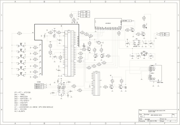
Diagram of a homemade navigator

The circuit is built on an ATMega64 microcontroller clocked from an external crystal resonator at 11.0592 MHz. The NEO-6M from U-blox is responsible for working with GPS, although it is an old, but very common and inexpensive module with a fairly accurate determination of coordinates. The information is shown on the display from Nokia 3310 (5110). The scheme also contains HMC5883L magnetometer and ADXL335 accelerometer.

HMC5883L a fairly common and inexpensive sensor, a standard I 2 C interface is used to communicate with the microcontroller.
The chip comes in a tiny 16-pin 3x3mm LPCC package.
Pin designation:
- SCL - I2C bus clock input
- VDD - input for connecting power (this bogeyman is fed with a voltage in the range of 2.16-3.6 volts)
- not used
- S1 - additional power supply for I / O ports. Connects directly to the VDDIO pin
- not used
- not used
- not used
- SETP - the first input for connecting a ceramic capacitor at 0.22uF
- GND - ground
- C1 is another input for connecting a capacitor. Electrolytic or 4.7uF tantalum (capacitor other end connected to ground)
- GND - ground
- SETC - the second input for connecting a ceramic capacitor at 0.22uF
- VDDIO - input for connecting the voltage that will be on the input / output ports
- not used
- Interrupt output when data is ready a logic 1 appears on this pin
- SDA - data line of the I2C interface
Navigator PCB

The circuit and the board are designed in the EasyEDA system.


The device is switched on and off by long pressing the S5 button. After turning on and searching for satellites (with a cold start, it can take up to 10 minutes or even more), we can view the current coordinates by pressing the S2 button.

The coordinates of the end point can be viewed by pressing the button S3.

Pressing the S4 button we get to the point saving menu. There are two ways to save a point:
- save current coordinates


2. hammer coordinates manually


Enter degrees, minutes and seconds in turn. The selected value for editing blinks.
You can return to the mode of following to the point by short pressing the button S5

Now about using the magnetometer and accelerometer. To calculate the azimuth, the data obtained from the GPS receiver are used, therefore, if it is not possible to calculate the coordinates (for example, if the satellites are not visible or there are few of them), it becomes possible to calculate the direction in which you need to move in order to come to the point. And originally my idea was to use the magnetometer as an aid to indicate the course. But I ran into some difficulties.
At first. Those who got acquainted with the work of digital magnetometers know that the accuracy of their data depends on what position they are in. Therefore, for correct operation in any position, it is necessary to use an accelerometer, which would give a more accurate picture of the projection of the magnetic field on all three axes of the magnetometer. I saw a possible solution to this problem in one magazine. but have not yet mastered the transfer of the entire calculation to Bascom (maybe someone from the enthusiasts will take it?).
Secondly, the difference in magnetic declination in different parts of the Earth is noticeable. For example, in the Volga region, the magnetic declination is 13 °, and at the other end of the country, the declination is already 11 ° and in the other direction. But there is also a magnetic inclination - when the magnetic field lines enter or exit at an angle to the horizon, and many other factors affecting the readings.
Of course, you can use such uncalibrated data from the magnetometer to roughly indicate the direction, but for now I decided to leave this idea behind and made a simple compass, which can also be useful. The compass is activated by pressing the S1 button. And in order for it to indicate a more or less correct direction to the north (more precisely to the north magnetic pole), the device must be held horizontally. To help with this, two dashes run along the sides of the screen, which show the tilt to one side or the other.
It remains to print the case on a 3-D printer for the device, but for now, about the results of street tests. The device turned out to be very interesting and very much even helping to get to the saved point. But you need to understand that millimeter accuracy should not be expected. An error in determining the GPS coordinates of just one second will give an inaccuracy in determining the position of 20 meters. Also, the error inevitably accumulates when rounding in mathematical calculations. But nevertheless, the device, even in dense urban conditions, made it possible to return to the point with an accuracy of several meters.

This device will become an indispensable assistant for those who like to wander through the forest, mushroom pickers, skiers, tourists and other nature lovers!
Components used in the device (they can be ordered from an online store from China):
- GPS module NEO-6M
- LCD display
- HMC5883 magnetometer
- Accelerometer ADXL335
Guide housing


P.S. At the request of users, I updated the firmware (two firmwares from the link above), excluding the accelerometer and magnetometer from the circuit. Now, by pressing the S1 button, information about the voltage on the battery, the time and date in UTC, as well as the azimuth - the same compass will be displayed 🙂
Violation of the speed limit in the city often leads to unjustified and tragic events. Therefore, in particularly important places, near busy intersections, schools, hospitals and public buildings, it is customary to install "speed bumps", which restrain the ardor of excessively zealous drivers. However, not for all drivers ... Read more

 switch")


 If you change the processor, what will change in the computer")


 Cobra")


